i-Boating:Norway Marine Charts 102.0
Paid Version
Publisher Description
This App offers access to Norway offline nautical charts, lake & river navigation maps for fishing, kayaking, boating, yachting & sailing. Coverage includes marine vector charts, freshwater lake maps, and inland river maps (HD/1ft/3ft bathymetry included where available). First marine GPS app to have route assistance with Voice Prompts for marine navigation. You can create new boating routes or import existing GPX/KML routes. It supports Nautical Charts course up orientation. Includes Tide & Currents prediction.
►FEATURES
√ Download Beautiful & detailed Hardware/GPU accelerated vector charts (text stays upright on rotation)
√ Query details of Maritime object (Buoy, Lights, Obstruction etc).
√ Custom depth(Ft/Fathom/Meter) & distance units (km/mi/NM)
√ Custom Shallow Depth.
√ Record tracks, Autofollow with real-time track overlay & predicted path vector.
√ Voice Prompts for marine navigation (requires GPS )
√ 1ft / 3ft depth contour maps for anglers for selected lake maps. Useful for fishing/trolling(freshwater/saltwater).
√ Supports GPX/KML for boating route editing/import.
√ Tide & Currents.
√ Seamless chart quilting. Map details from Coastal, Approaches,Harbour, Inland Encs(rivers), and general ENC (Electronic Marine Charts) are automatically mapped to correct zoomlevel
√ Enter / import Waypoints.
► MAPS
√ Norway Marine Charts
►ROUTE MANAGEMENT / TRIP PLANNING
√ Create New /Edit Routes
√ Reverse Routes
√ Enter,Move, Add, Delete, Rename Waypoints
√ Import GPX, KML & KMZ files
√ Plot/Edit Routes
√ Share/Export Routes, Tracks & Markers
►GPS FEATURES
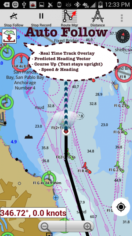
√ Auto Follow
* Real Time Track Overlay
* Predicted Path Vector
* Course Up (Text stays upright)
* Speed & Heading
√ Route Assistance With Voice Prompts
* Prompts when approaching a boating route marker
* Continous distance & ETA updates
* Alerts when sailing/boating off route
* Alerts when boating in wrong direction
√ Record Tracks
►TIDE & CURRENTS
* For US, Canada, UK,Germany&New Zealand
* High/Low Tides
* Tidal Current Prediction
* Active Current Stations
► SHARING
* Share tracks/routes/markers on Facebook & Twitter
* Export tracks/routes/markers as compressed GPX files.
Sample Maps (See http://goo.gl/IoQsog for full list)
Grimstad
Alsten
Vestre Senja
Storegga
Laksefjorden
opsfjorden
Barentsburg
Lillesand - Kristiansand
Skagerak
Steinkjer
Hylsfjorden
Tanafjorden
Sognefjoden
Svalbard Moffen
Varangerfjorden
Skillebotnfjorden
Svalbard
About i-Boating:Norway Marine Charts
i-Boating:Norway Marine Charts is a paid app for Android published in the Recreation list of apps, part of Home & Hobby.
The company that develops i-Boating:Norway Marine Charts is Gps Nautical Charts. The latest version released by its developer is 102.0.
To install i-Boating:Norway Marine Charts on your Android device, just click the green Continue To App button above to start the installation process. The app is listed on our website since 2017-01-04 and was downloaded 30 times. We have already checked if the download link is safe, however for your own protection we recommend that you scan the downloaded app with your antivirus. Your antivirus may detect the i-Boating:Norway Marine Charts as malware as malware if the download link to com.skiracer.nautical_astore_no is broken.
How to install i-Boating:Norway Marine Charts on your Android device:
- Click on the Continue To App button on our website. This will redirect you to Google Play.
- Once the i-Boating:Norway Marine Charts is shown in the Google Play listing of your Android device, you can start its download and installation. Tap on the Install button located below the search bar and to the right of the app icon.
- A pop-up window with the permissions required by i-Boating:Norway Marine Charts will be shown. Click on Accept to continue the process.
- i-Boating:Norway Marine Charts will be downloaded onto your device, displaying a progress. Once the download completes, the installation will start and you'll get a notification after the installation is finished.
